| |
Trip West - 2018 |
|
| |
|
|
| |
Monument Valley | Page Arizona
| Grand Staircase Escalante
| Zion | Moab
| Capital Reef |
Bryce Canyon |
Cedar Breaks |
|
| |
|
|
| |
|
|
| |
|
|
| |
This trip will last around 10 days and
will go through the states of Missouri, Kansas, Colorado, Utah and
northern Arizona. It will probably entail a journey of some 2,000 miles
before we reach our final destination at Casa Budde West.
We will depart from St. Louis on Wednesday May 23 and arrive in Driggs
around Memorial Day. |
|
| |
|
|
| |
The main photography objectives of this trip
are: |
|
| |
|
|
| |
| |
Monument Valley in northern
Arizona |
| |
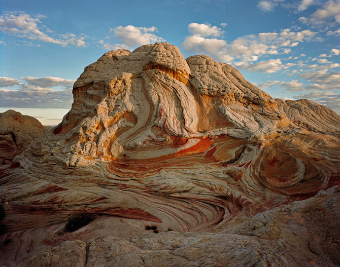
Grand Staircase Escalante National
Monument |
| |
Zion National Park |
|
|
| |
|
|
| |
If we have time, we will also stop by
Bryce Canyon National Park (see below) since it will be on the way.
After we leave Zion, we will also visit with Ted & Paulette
Roche and Andy Odenwald in Salt Lake City on the way to Driggs. |
|
| |
|
|
| |
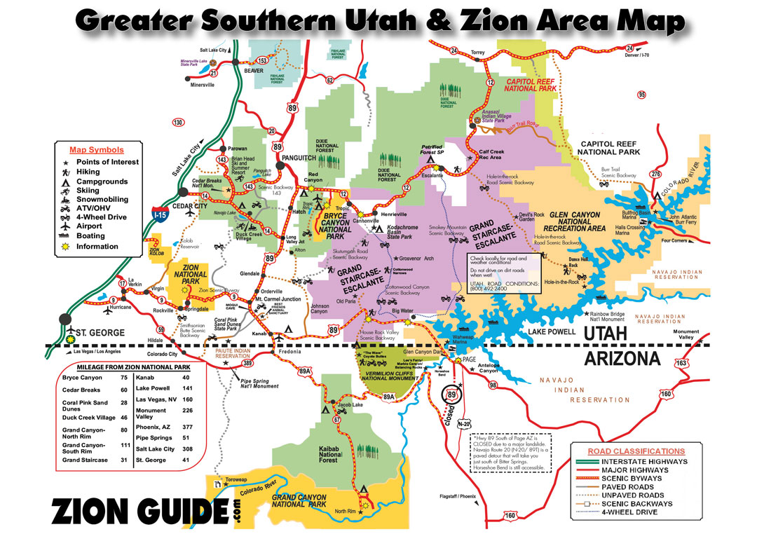
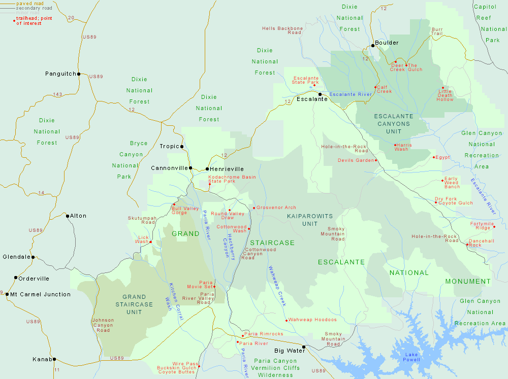
This map should give you some idea of
where everything is located in relation to the others areas we will be
visiting. |
|
| |
|
|
| |
 |
|
| |
|
|
| |
|
|
|
|
|
| |
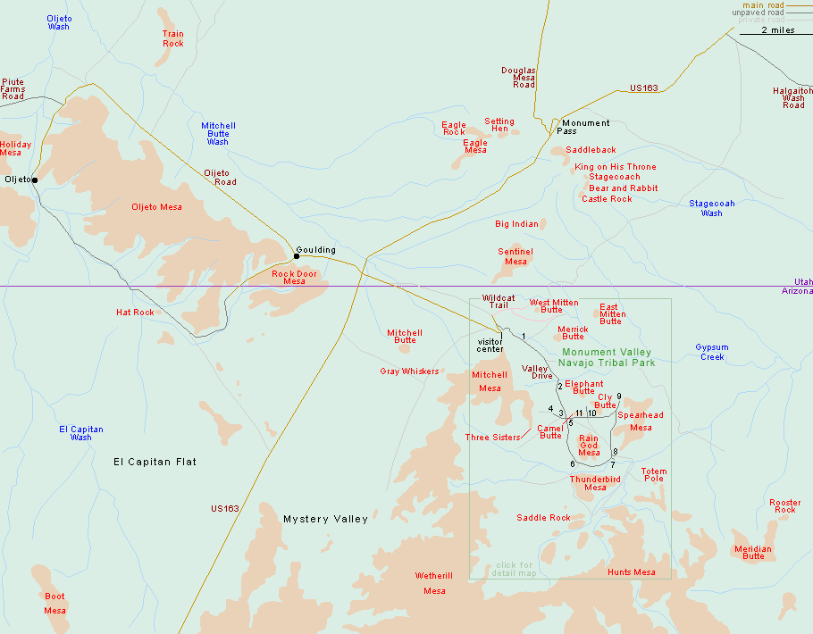
Monument Valley Navajo Tribal Park |
|
| |
Destination 1 |
|
| |
|
|
| |
 |
|
| |
|
|
| |
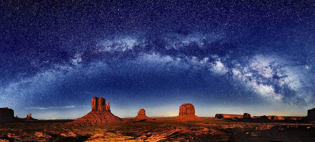
Monument Valley is located in the Monument
Valley Navajo Tribal Park. You will probably remember the classic scene
from the movie Forrest Gump where Forest is running across the US. He is
running done a road with these dramatic spires in the distance.
We can either do this park on our own or hire a guide to take us around. |
|
| |
|
|
| |
Distance from St. Louis: 1285 miles and 20
hours drive time. If we make it to Colorado Springs the first day (800
miles and 12 hour drive time) the second day will entail 485 miles and a
8:35 drive time. |
|
| |
|
|
| |
Lodging options:
Valley of the Gods Bed & Breakfast (970-749-1164)
Monument Valley: The View Hotel (435-727-5555)
Mexican Hat: San Juan Inn (800-447-2022)
Goulding's Lodge (435-727-3231) - I saw a YouTube video where a
fellow stayed here and it was a nice location |
|
| |
|
|
| |
Dining options:
Kayenta AZ: Amigo Cafe, The Blue Coffee Pot
Mexican Hat: Olde Bridge Grill |
|
| |
|
|
| |
Photography Plan: |
|
| |
|
|
| |
Arrive early afternoon on May 24. Scout
for sunset locations. Take photos. Spend May 25 taking more photos and
visiting Natural Bridges, Valley of the Gods, Bears Ears and time
permitting Rainbow Bridge.
Note: there are
tour
options we may want to investigate
Drive to Page Arizona late May 26. |
|
| |
|
|
| |
Park Web Site Map
Info
Video
Drone Flying
Southern Utah & Arizona video |
|
| |
|
|
| |
|
|
| |
|
|
| |
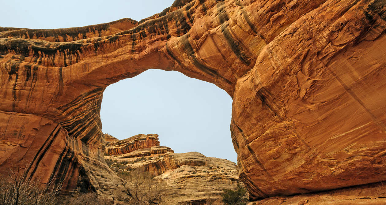
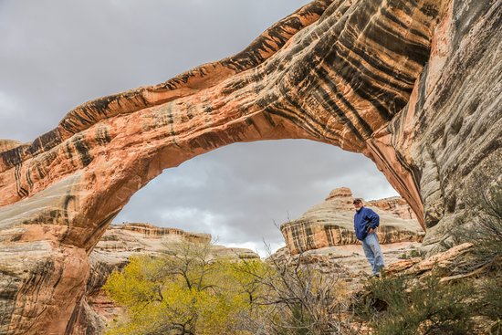
Attraction: Natural Bridges National Monument |
|
| |
|
|
| |
|
|
| |
|
|
| |
This is near Valley of the Gods and
Bears Ear described below.
The monument protects three natural bridges: Sipapu
Bridge, Kachina
Bridge,
and Owachomo
Bridge.
Trailheads and overlooks for each bridge are located along the main
driving loop. |
|
|
|
|
| |
Distance from
Monument Valley Utah: 70 miles and 1:30 drive time |
|
| |
Web site Map
Video
Info |
|
| |
|
|
| |
|
|
| |
|
|
| |
Attraction: Valley of the Gods |
|
| |
|
|
| |
 |
|
| |
|
|
| |
The Valley of the Gods Road runs between Highways 163 and 261. The road
forks away from Hwy 163 about 7.5 miles north of Mexican Hat. It winds
north and west and then connects with Hwy 261 about 6.5 miles northwest
of the point where Hwy 261 forks from Hwy 161.. |
|
| |
|
|
| |
Distance from Monument Valley Utah: 35 miles and
50 minute drive time. |
|
| |
Web Site
Map
Video |
|
| |
|
|
| |
|
|
| |
|
|
| |
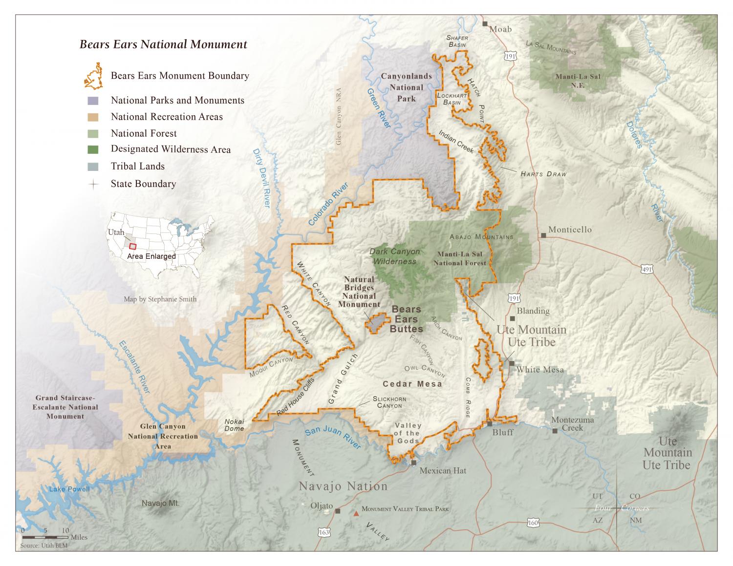
Attraction: Bears Ears |
|
| |
|
|
| |
 |
|
| |
|
|
|
Bears Ears National Monument is located west
of the towns of Blanding, Monticello and Bluff and
north of Mexican Hat in southeastern Utah's San Juan County.
It is located a few minutes west of Bluff on U.S. 163 en route to
Monument Valley Navajo Tribal Park. The best place to see the iconic
view of the Bears Ears is from State Route 261 traveling north towards
Highway 95. |
|
| |
|
|
| |
Distance from Monument Valley Utah: 70 miles and
1:35 drive time. |
|
| |
Web Site Map
Video |
|
| |
|
|
| |
|
|
| |
|
|
| |
Attraction: Rainbow Bridge National Monument |
|
| |
|
|
| |
 |
|
| |
|
|
| |
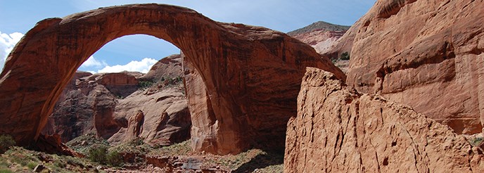
This is located east of Monument Valley
close to Lake Powell.
Rainbow Bridge is one of the world's largest known natural bridges.
Rainbow Bridge National Monument is located between Glen Canyon National
Recreation Area and the Navajo Nation. There are no roads in the
vicinity of the monument. Rainbow Bridge can be reached by boat on Lake
Powell. |
|
| |
|
|
| |
Distance from Monument Valley Utah: xx
miles and x:yy drive time. |
|
| |
Web Site
Video
More |
|
| |
|
|
| |
|
|
|
|
|
| |
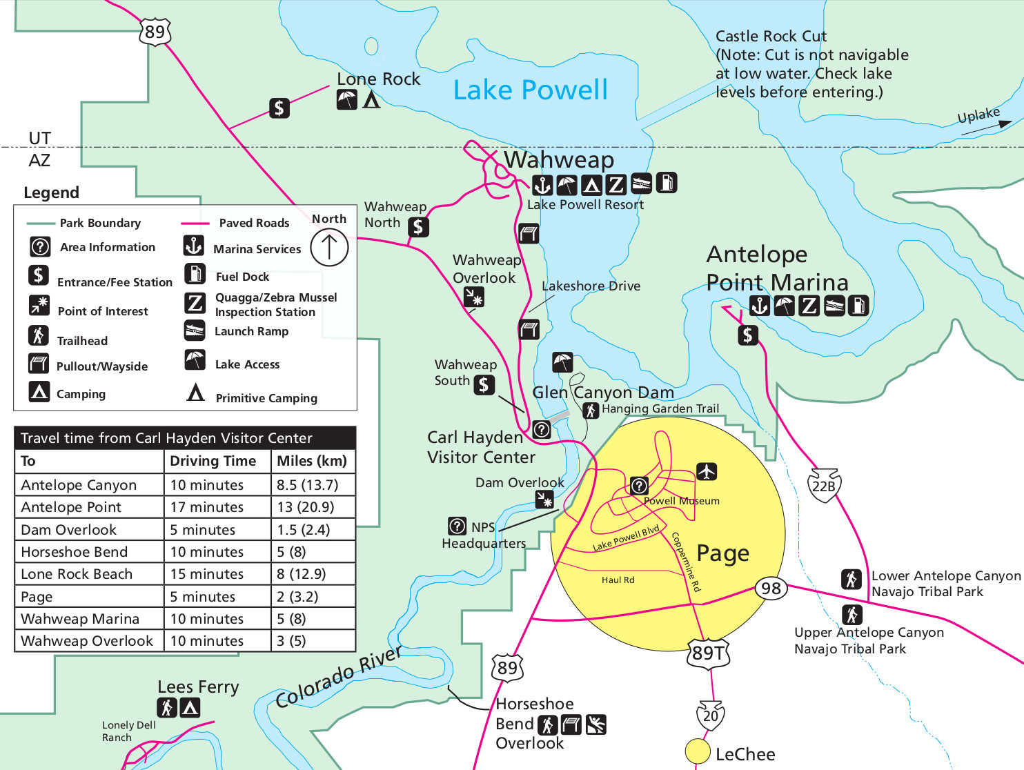
Around Page, Arizona |
|
| |
Destination 2 |
|
| |
|
|
| |
 |
|
| |
|
|
| |
Distance from Monument Valley Utah to Page
Arizona: 120 miles and 2 hours drive time. |
|
| |
|
|
| |
Photography Plan: |
|
| |
|
|
| |
Spend May 27 in the area investigating
Antelope Canyon and The Wave / Coyote Buttes.
Drive to Grand-Staircase Escalante the morning of May 28. |
|
| |
|
|
| |
Lodging: Page Arizona |
|
| |
|
|
| |
|
|
| |
|
|
| |
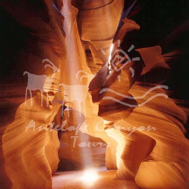
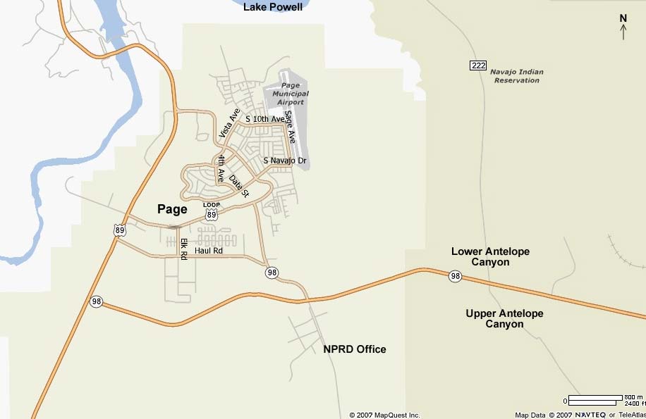
Attraction: Antelope Canyon |
|
| |
|
|
| |
 |
|
| |
|
|
| |
Distance from Page: 8 miles and 15 minutes drive
time. Guided
tours into Upper
Antelope Canyon are
subjected to passenger
limits,
we highly suggest booking a tour in Advance, from
the months
of March to October Reservations
are Required
(see Park Web Site link below)
Our tours into the Upper Antelope Canyon begin at our office located at 22
South Lake Powell Boulevard,
near the intersection of Lake Powell Boulevard and North Navajo Drive in
the heart of Page,
AZ.
Look for the monster trucks! Call or email for directions. |
|
| |
|
|
| |
I suspect that being able to take photos without
a bunch of folks in them will be quite problematic. We might want to
skip this. The Lower Canyon tour is supposed to be less crowded than the
popular Upper Canyon. It is however quite a bit more strenuous to
navigate and requires some climbing. |
|
| |
|
|
| |
Park
Web Site Map
Video |
|
| |
|
|
| |
|
|
| |
|
|
| |
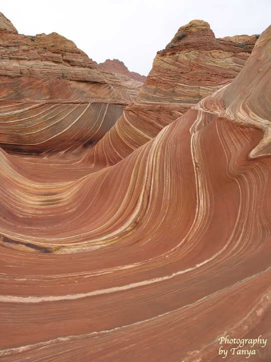
Attraction: The Wave / Coyote Buttes |
|
| |
|
|
| |
 |
|
| |
|
|
| |
Distance from Page: 45 miles and 1 hour
drive time. This requires a hike of 5.5 miles to The Wave and back. See
web site link for more details. |
|
| |
|
|
| |
Park
Web Site
Map Info
Photos
Video
Video |
|
| |
|
|
| |
|
|
| |
|
|
| |
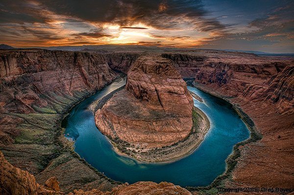
Attraction: Horseshoe Bend |
|
| |
|
|
| |
 |
|
| |
|
|
| |
Web site
Best
time to visit |
|
| |
|
|
| |
|
|
|
|
|
| |
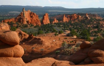
Grand Staircase-Escalante National Monument |
|
| |
Destination 3 |
|
| |
|
|
| |
 |
|
| |
|
|
| |
Distance from Page Arizona to Tropic Utah:
155 miles and 2:40 drive time but there will be some stopping along the
way for photography. |
|
| |
|
|
| |
Photography Plan: |
|
| |
|
|
| |
On May 28, stop and take photos at Lower
Calf Creek Falls, Grosvenor Arch and Kodachrome Basin State Park along
our northerly drive. Head on over to the other "loop" and take photos of
Devil's Garden and Dancehall Rock. |
|
| |
|
|
| |
Note: we might want to consider a
tour |
|
| |
|
|
| |
Lodging options |
|
| |
Boulder: Boulder Mountain Lodge
(435-335-7460), Circle Cliffs Motel (435-335-7333) |
|
| |
Escalante: Canyons Bed & Breakfast
(435-826-4747) |
|
| |
|
|
| |
Dining options |
|
| |
Escalante: Burr Trail Grill, Cowboy Blues,
Circle D Eatery |
|
| |
Boulder: Hell's Backbone Grill
(reservations recommended ) |
|
| |
Torrey: Cafe Diablo |
|
| |
|
|
| |
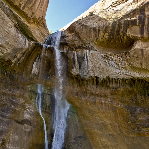
Attraction: Lower Calf Creek Falls |
|
| |
|
|
| |
 |
|
| |
|
|
| |
A delightful hike that ends at a 126 foot
waterfall.
The trailhead is in the Calf Creek Recreation Area, which is on Utah
State Highway 12, about 15 miles east of Escalante, UT.
See web site for more details about this attraction. |
|
| |
|
|
| |
Web Site
Video |
|
| |
|
|
| |
|
|
| |
|
|
| |
Attraction: Upper Calf Creek Falls |
|
| |
|
|
| |
Upper Calf Creek Falls Trail is a 2 mile moderately trafficked out and
back trail located near Boulder, Utah that features a waterfall and is
rated as moderate. |
|
| |
|
|
| |
Web Site |
|
| |
|
|
| |
|
|
| |
|
|
| |
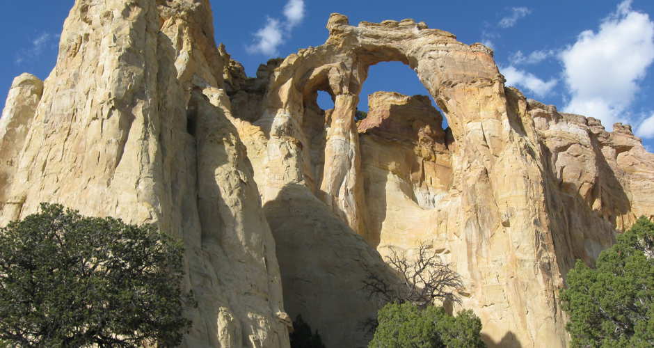
Attraction: Grosvenor Arch |
|
| |
|
|
| |
 |
|
| |
|
|
| |
Grosvenor Arch trail is a 0.2 mile lightly trafficked out and back trail
located near Cannonville, Utah |
|
| |
|
|
| |
Web Site
Video |
|
| |
|
|
| |
|
|
| |
|
|
|
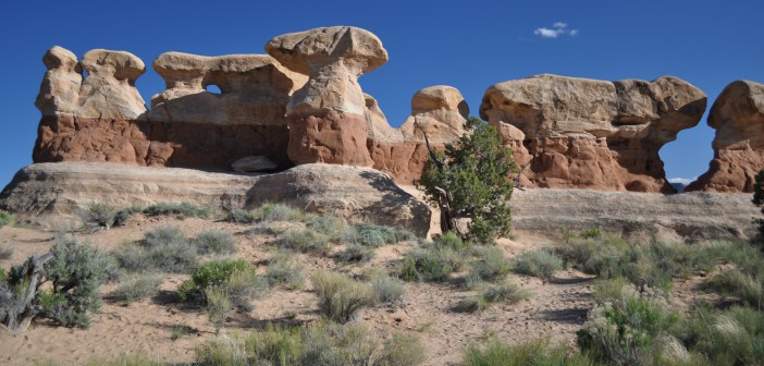
Attraction: Kodachrome Basin State Park |
|
| |
|
|
| |
 |
|
| |
|
|
| |
There are several trails here to explore
this park... Trails Grand Parade trail and Angel's Palace trail. Click
on the web site link below for more details. From the write-up it would
seem that the second would be preferred for photography. Each is listed
as 1.5 miles in length. |
|
| |
|
|
| |
Web
Site |
|
| |
|
|
| |
|
|
| |
|
|
| |
Attraction: Devil's Garden |
|
| |
|
|
| |
 |
|
|
|
|
| |
A short 0.5 mile hike.
From Escalante, Utah, take the main road, Highway 12, east through
Escalante. The road will head in a southeastern direction. Follow Hwy 12
for five miles, and as the highway makes a left curve, the unpaved Hole
in the Rock Road will be on the right side of the road. If you were to
go straight instead of take the curve that would turn into Hole in the
Rock Road. |
|
| |
|
|
| |
Web Site
Video |
|
| |
|
|
| |
|
|
| |
|
|
| |
Attraction: Dancehall Rock |
|
| |
|
|
| |
 |
|
| |
|
|
| |
About 42 miles south of Escalante, back-country travelers will find
Dance Hall Rock. |
|
| |
|
|
| |
Web Site |
|
| |
|
|
| |
|
|
| |
|
|
| |
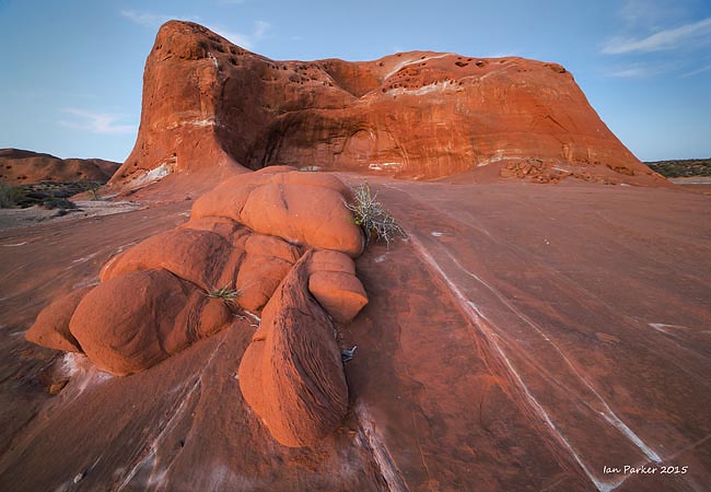
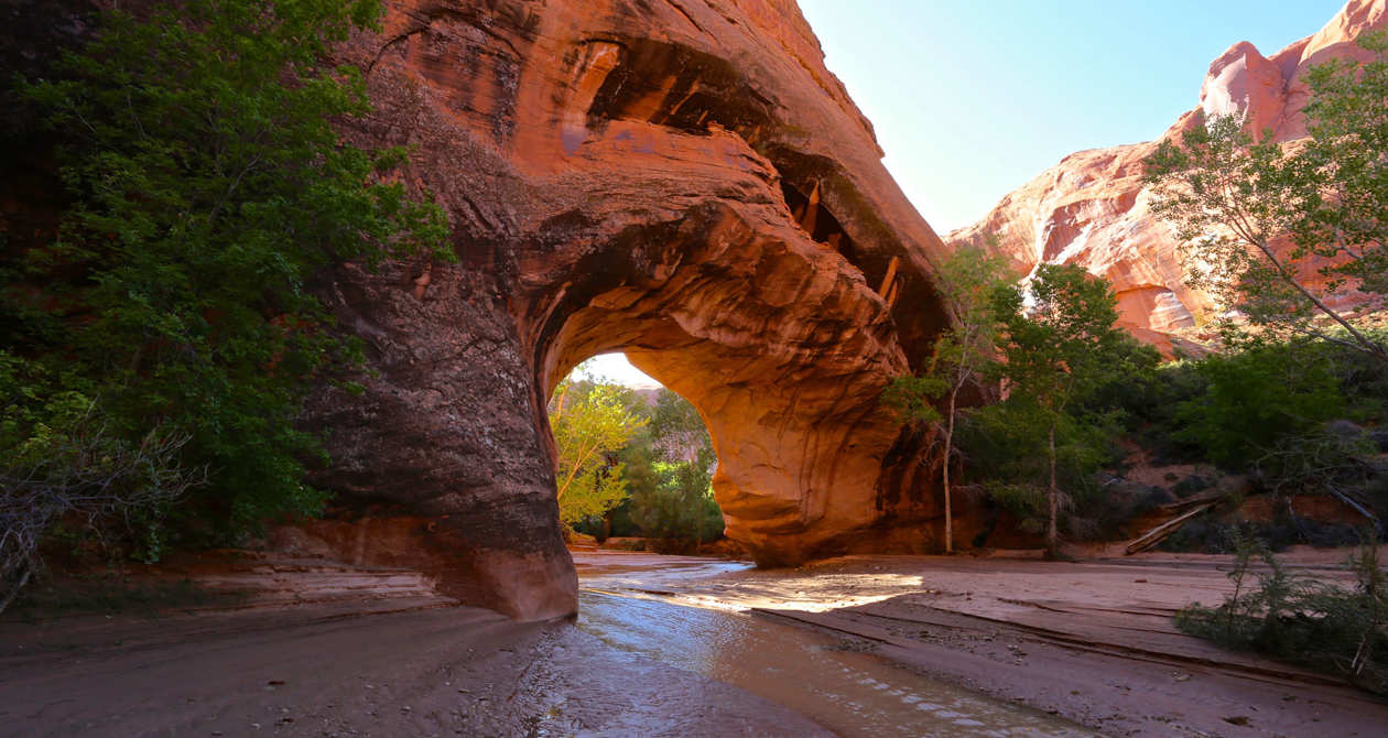
Attraction: Coyote Gulch |
|
| |
|
|
| |
 |
|
| |
|
|
| |
Coyote Gulch at Grand Staircase-Escalante National Monument, Utah,
offers photogenic views of natural arches above a present-day
watercourse.
Access to this canyon is by backpacking along a trail that follows the
creek. You’ll need to frequently walk in the creek, so choose
appropriate footwear. |
|
| |
|
|
| |
Web Site Another
Video |
|
|
|
|
| |
Hike of 11.5 miles round trip - although
this is really, REALLY beautiful, we will probably skip this. |
|
| |
|
|
| |
Grand Staircase Escalante
Hikes |
|
| |
|
|
| |
|
|
|
|
|
| |
Bryce Canyon National Park |
|
| |
Destination 4 |
|
| |
|
|
| |
 |
|
| |
|
|
| |
Distance from Boulder:
80 miles and 1:45 drive time |
|
| |
|
|
| |
Drive from Grand Escalante on May 30 to Bryce
and then Zion |
|
| |
|
|
| |
Web Site Map
Video
My photos
Hikes |
|
| |
|
|
| |
|
|
| |
|
|
| |
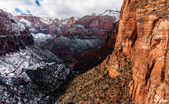
Zion National Park |
|
| |
Destination 5 |
|
| |
|
|
| |
Distance from Bryce Canyon National Park:
85 miles with a 2:00 drive time. |
|
| |
|
|
| |
Lodging: Springdale, La Verkin, Hurricane
or St. George. Last time I stayed at Rodeway Inn in Hurricane Utah
(~ $83 per night). |
|
| |
|
|
| |
 |
|
| |
|
|
| |
My main objective here is to catch some
photos of The Watchman at sunset with the Zion River in the foreground. |
|
| |
|
|
| |
IMPORTANT: Rodney Henry says there are
major delays getting into the Park from the south entrance due to road
construction. He suggests we go in through the east entrance. |
|
| |
|
|
| |
Photography Plans: |
|
| |
|
|
| |
Leave base for Grand Escalante the morning of May 28 and
drive to Zion National Park. Be on the bridge to take sunset photos of
the Watchman.
On May 31, take a trip down to Vermillion Cliffs. Head up to Salt Lake
City later that day. Spend Friday June 1 with Ted and Andy.
Drive to Driggs on June 2. |
|
| |
|
|
| |
Park Web Site Map
Guide
Video
Outdoor Photographer
Joe's Guide to Zion
National Park |
|
| |
|
|
| |
Photos I want to take:
Court of the Patriarches Watchman |
|
| |
|
|
| |
|
|
| |
|
|
| |
Attraction: Vermillion Cliffs |
|
| |
|
|
| |
 |
|
| |
|
|
| |
This area is due south of Zion National Park. |
|
| |
|
|
| |
Distance from Zion National Park: 50 miles
and 1:35 drive time |
|
| |
Park Web Site
Info
Map Tours
National Geographic Photos
Video |
|
| |
|
|
| |
Drive from Vermillion Cliffs to Salt Lake
City: 365 miles and 5:50 drive time. The drive from Salt Lake City to
Driggs is 285 miles and a 4:20 drive time. |
|
| |
|
|
| |
|
|
| |
Scharff Family Adventure |
|
| |
|
|
|
|
|
| |
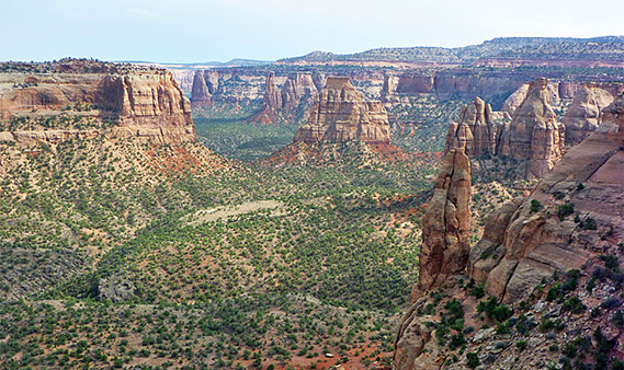
Colorado National Monument |
|
| |
|
|
| |
 |
|
| |
|
|
| |
This looks to be a very scenic drive.
Since the drive from Granby to Moab is just over 5 hours, you may want
to consider taking a side trip through the Colorado National Monument
around Grand Junction. |
|
| |
|
|
| |
Web site
Map |
|
| |
|
|
| |
|
|
| |
|
|
| |
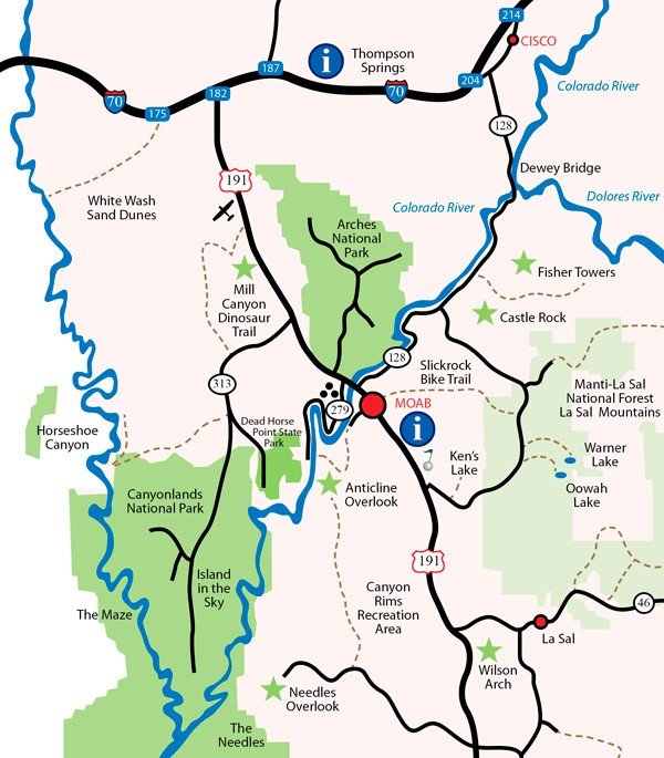
Around Moab Utah |
|
| |
|
|
| |
 |
|
| |
|
|
| |
Based in Moab, you can take in Arches,
Highway 128, Dead Horse Point and Canyonlands. I stayed at the Rodeway
Inn & Suites (~ $190 per night). They had a pool as I recall.
Note: driving distance from Granby to Moab is 310 miles and just
over 5 hours drive time. |
|
| |
|
|
| |
|
|
| |
|
|
| |
Attraction: Arches National Park |
|
| |
|
|
| |
|
|
| |
|
|
| |
I was last here in the spring of 2015.
|
|
| |
|
|
| |
Distance from Moab: 4.5 miles |
|
| |
Main attractions: Park Avenue, Three
Gossips, Courthouse Towers, Balanced Rock, Garden of Eden, Double Arch,
Turret Arch, North & South Window, Delicate Arch, Landscape Arch, Double
O Arch |
|
| |
|
|
| |
Park Web Site Map
Outdoor Photographer
My photos
Video |
|
| |
|
|
| |
|
|
| |
|
|
| |
Attraction: Highway 128 |
|
| |
|
|
| |
|
|
| |
|
|
| |
|
|
| |
This is a right hand turn just before
crossing the Colorado River on the way to Arches National Park coming
from Moab. |
|
| |
|
|
| |
Distance from Moab: 3 miles |
|
| |
Map
Info
Video |
|
| |
|
|
| |
|
|
| |
|
|
| |
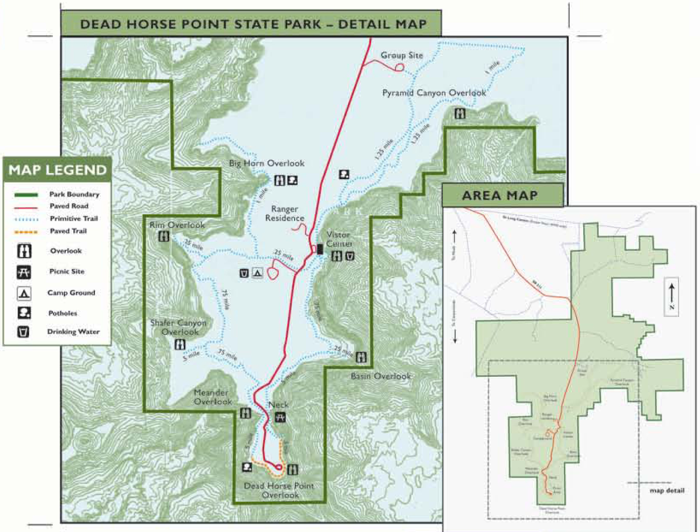
Attraction: Dead Horse Point State Park |
|
| |
|
|
| |
|
|
| |
|
|
| |
|
|
| |
I was last here in the spring of 2015. As
you can see from the photos above, this is a "don't miss" scenic opportunity!
This can be combined with a day trip to Canyonlands National Park. |
|
| |
|
|
| |
Distance from Moab: 32 miles |
|
| |
Web Site
Link
Map
Video |
|
| |
|
|
| |
|
|
| |
|
|
| |
Attraction: Canyonlands National Park |
|
| |
|
|
| |
|
|
| |
|
|
| |
I was last here in the spring of 2015.
This is reached as a daytime drive from Moab Utah. |
|
| |
|
|
| |
Distance from Dead Horse Point: 12 miles |
|
| |
Main attractions: the various overlooks,
hike to Mesa Arch |
|
| |
Web Site Map
My photos
Video |
|
| |
|
|
| |
|
|
|
|
|
| |
Driving West from Moab |
|
|
|
|
| |
If you want to
continue westward from Moab for a bit here are some options you might
want to consider. |
|
| |
|
|
| |
Attraction: Highway 12 |
|
| |
|
|
| |
This is a beautiful scenic drive that you
can take if you are going to visit some of the other places listed
below. |
|
| |
|
|
| |
Driving Utah's Scenic ByWay
Scenic ByWay 12 |
|
| |
|
|
| |
|
|
| |
|
|
| |
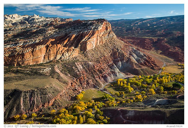
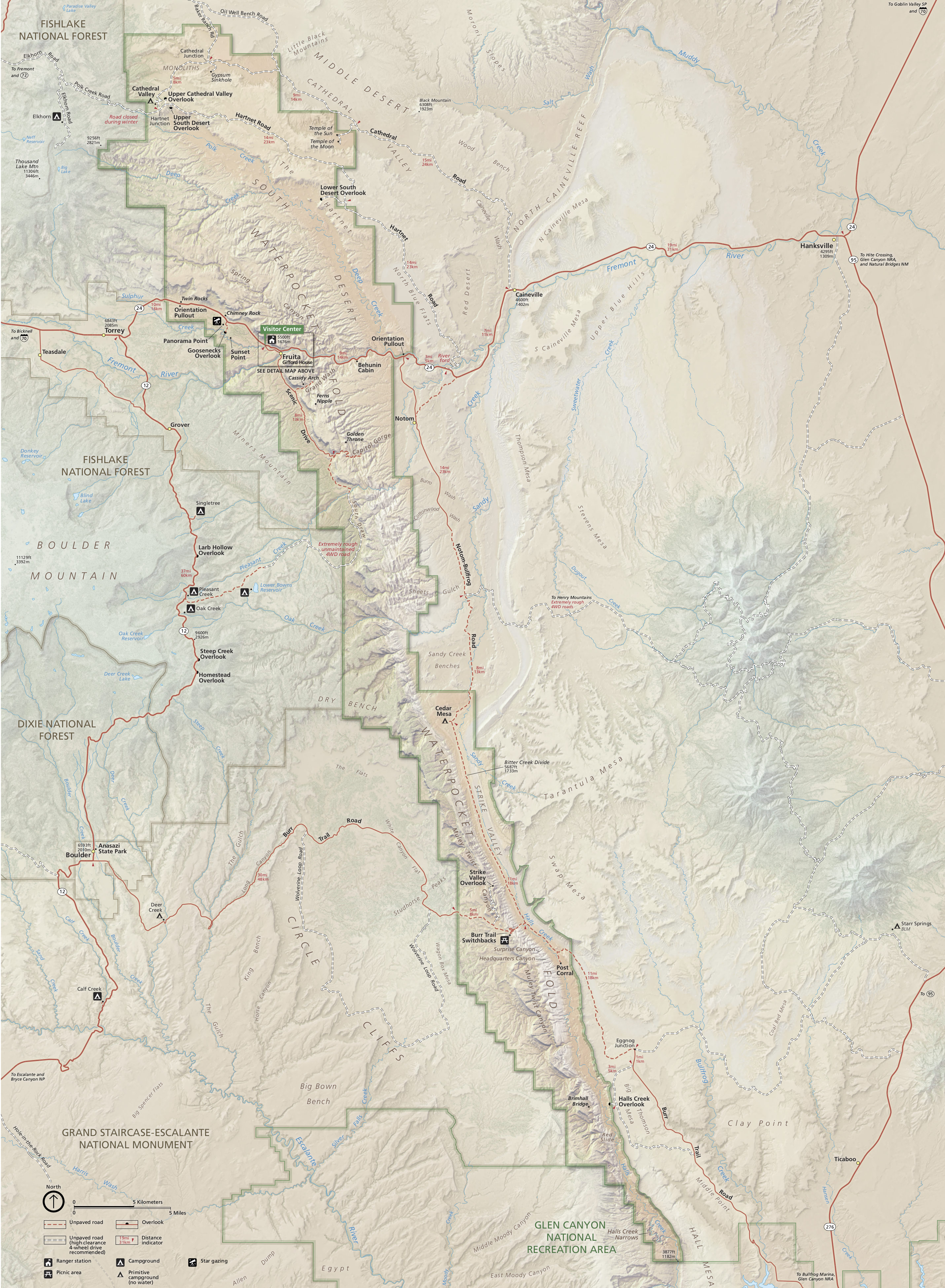
Attraction: Capital Reef National Park |
|
| |
|
|
| |
|
|
| |
|
|
| |
I was last here in the spring of 2015. |
|
| |
|
|
| |
Distance from Moab: 140 miles and just over 2
hours drive time. |
|
| |
Main attractions: Hickman Bridge (above), |
|
| |
Park Web Site Map
Video
My photos
More photos |
|
| |
|
|
| |
|
|
|
|
|
| |
Attraction: Bryce Canyon National Park |
|
| |
|
|
| |
|
|
| |
|
|
| |
I was last here in the spring of 2015.
This area is famous for its "hoodoos". I stayed at the Best
Western Plus Ruby's Inn in Bryce City. (~ $155 per night) |
|
| |
|
|
| |
Distance from Capital Reef National Park:
120 miles and 2:20 drive time |
|
| |
Distance from Bryce City Utah: 2 miles |
|
| |
Main attractions: |
|
| |
Web Site Map
Video
My photos
Hikes |
|
| |
|
|
| |
|
|
|
|
|
| |
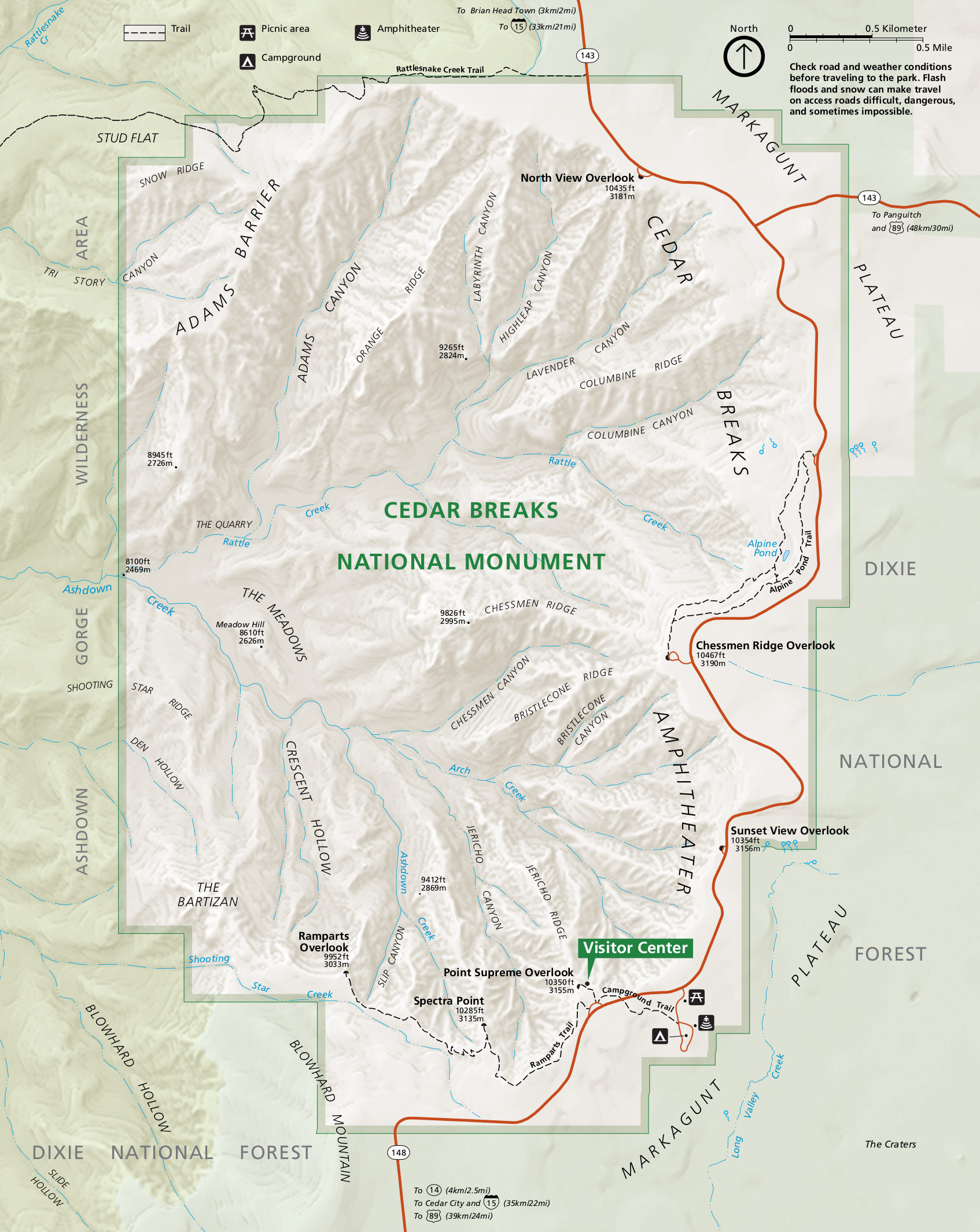
Attraction: Cedar Breaks National Monument |
|
| |
|
|
| |
|
|
| |
|
|
| |
I was last here in 2015. This is a high
altitude location... around 10,000 feet. I stayed at the Days Inn in
Panguitch Utah (~ $90 per night) |
|
| |
|
|
| |
Distance from Bryce Canyon National Park:
55 miles and 1:10 drive time |
|
| |
Distance from Panguich: 31 miles and 40 minutes
drive time |
|
| |
Distance from Cedar City Utah: 45 miles and 35
minutes drive time |
|
| |
|
|
| |
Web Site
Info Map
Video |
|
| |
|
|
| |
|
|
| |
|
|
| |
If you are feeling really ambitious, you
could drive all the way to Zion National Park (see above). 70 miles and
a 1:30 drive time |
|
| |
|
|


